|
|
|
|
Summary:
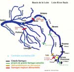
NB : this presentation of the « Plan Loire Grandeur Nature » has been compiled by European Rivers Network from documents of the French Ministry of the Environment dating back to 1994, when the Plan Loire was announced. It explains the goals and means of the Plan Loire as it was launched in 1994 and does not represent the opinions of ERN concerning the management of the Loire. The words to click will take you to pages under construction where ERN gives the position of the environmentalists and indicates how far the goals have been fulfilled. On January 4th, 1994, Michel Barnier, Minister of the Environment, announced a long-term management plan for the Loire river and its watershed, which was called « Plan Loire Grandeur Nature ». Plan Loire is an attempt to reconcile local and regional dependence on riverine resources with the rivers importance to France as a national treasure. It represents the first governmental effort to devise and implement a river management strategy which considers a basin of this magnitude in its entirety and over the long term. The goals are to mitigate the impacts of centuries of habitation and resource development without disrupting the rivers economic contribution to Frances economy, to protect and preserve the native character of the watershed for future generations, and to provide and maintain flood control for the security of the Loire valleys residents, while allowing the natural hydrologic cycles necessary for a healthy living river. This program stems from a wide debate over the management of the Loire which began in 1986. That year, the EPALA (a body of local basinwide authorities aiming at managing the Loire and its tributaries) signed with the government and the Loire-Bretagne Water Agency an agreement aiming at building 4 new dams: Serre de la Fare on the Upper Loire, Chambonchard on the Cher river, Naussac II and Le Veurdre on the Allier river, as well as several hundreds of kilometers of new dikes. A few months later, the Loire Vivante committee - supported by WWF-France (World Wide Fund for Nature) - was created to oppose this program. This network comprises several NGOs local on the Loire basin. With the creation of SOS Loire Vivante in 1988, which occupied the Serre de la Fare dam site as of 1989, the campaign for a « living Loire » took an unprecedented turn in France and drew attention from national and international media on the management of the « last wild river in Europe ». A first
governmental decision was taken in 1991 by the socialist government
of Prime Minister Cresson. It announced the cancellation of Serre
de la Fare and Chambonchard, the postponement of Le Veurdre and the
construction of Naussac II. But it did not end the debate as it did
not clearly propose alternative solutions to dams - notably for Serre
de la Fare. With the change of government in 1993, the debate was
revived until the Plan Loire was decided early in 1994.
The
Plan Loire Grandeur Nature 1994 consists in 4 parts : The actors - A global program for the LoireThe Loire river is Frances largest river, draining a fifth of the country. Its 685 miles, flowing through 6 regions and 11 « départements » (French equivalent to countries), support agriculture, river navigation, fisheries and hydro and nuclear electrical generation. The river, its tributaries and associated habitats and wildlife constitute a natural ecosystem exceptional in Europe.1. A global
program for the Loire The Plan Loire is integrated into the states effort to devise a blueprint for managing and developing the Loire basins water resources (Schéma Directeur dAménagement et de Gestion des Eaux - SDAGE). This SDAGE is elaborated by the Loire-Bretagne Basin Committee formed by local authorities, representatives of the industry, governmental agencies and environmental organizations. 2. Partnership
with the authorities in charge of the basin Man - Ensuring security of the Loire valleys residents in case of floodsThe security of the Loire valleys residents is a priority of the Plan Loire. Increased settlement in the floodplains has created unacceptable risks, made worse by poor riverine management practices. Bad upkeep of the riverbed has increased these risks. 1. Identifying
the risks 2. Controlling
urbanization 3. Strengthening
the flood alarm system on the upper basins Plan Loire will implement an improved flood alarm system that will provide a 4 hours notice of impending high flows (instead of 2 hours previously). At the same time, local authorities will reinforce measures to evacuate people threatened by an impending flood. 4. Implementing
alternative solutions to damming on the Upper Loire 5. Implementing
specific measures for the Middle Loire Water - Responding to the needs for water supply on the Loire basinLow summer flows in the Loire and its tributaries allow higher concentrations of existing pollutants and constitute a threat to water supplies as well as to industrial and agricultural activities. Efforts have been made to protect water quality, including rationing and restricting discharges into the river. But more steps are necessary.1. Water
supply on the upper valleys of the Allier and Cher rivers
The government approves of the construction of the Chambonchard dam on the Upper Cher river. A 50 million m3 volume is judged sufficient to complete its primary goals : irrigation and sustaining low summer levels. In case local authorities would want to develop recreational activities around the reservoir, it is allowed that the reservoir would be 70/80 million m3. However, local authorities will have to finance the cost surplus. 2. Measures
against riverbed sinking Navigation between Bec de Vienne and Bouchemaine (Lower Loire) will no longer be allowed. Below Bouchemaine to the estuary, river level adequate for navigation will be maintained, and shipping will continue for 5 years, at which time it will be reevaluated. Nature - Protecting and restoring the rivers biodiversityThe Loire is among a handful of European rivers that retain some naturally functioning aquatic environments.1. A program to protect migrating fish The Plan Loire intends to protect these fish by improving water quality, fighting eutrophication and implementing a flow management strategy mimicking the variable flows essential to riparian renewal and the survival of migratory fish. For the first time ever in France, two dams are proposed for removal, the Maisons-Rouges dam on the Vienne river and the Saint-Etienne du Vigan dam on the Upper Allier. Other measures will be launched to improve fish ladders on other obstacles to salmon migration. For dams scheduled for relicensing, flow regimes will be examined to insure the passage of fish. 2. The
estuary Still, much of the estuarys natural heritage remains - it is even of a remarkable value on a European level. The French government expresses its commitment to its protection. The goal is to reconcile economic development and protection of the environment. To achieve these
goals, the following measures will be implemented : 4. Protection
of natural areas and landscapes
|